Networks Introduction
What is a Network?
A Network is a collection of locations. Each location consists of a point (where the location exists) and a surrounding Trade Area (defined as a collection of census areas). To read more on Census Areas and how the system uses them see here.
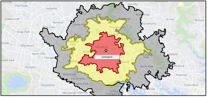
A single location that has a location point (Carlingford) and a user defined Trade Area (red, yellow and black regions) defined as 5, 10 and 15 minute drive times.
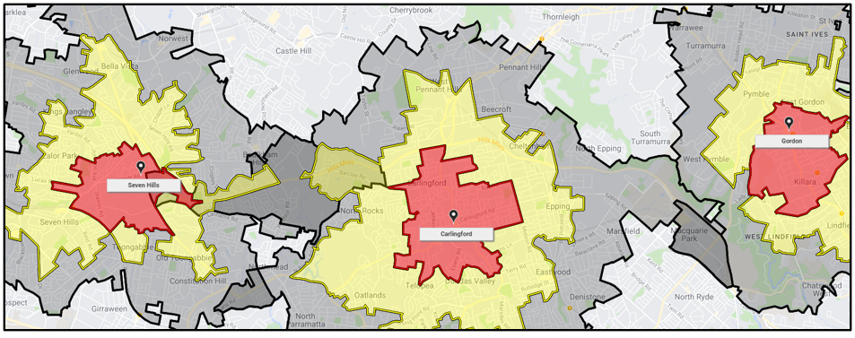
Multiple location points with Trade Areas.
What is a Trade Area?
Trade Areas represent a collections of census areas assigned to a location. They are split into three sections: Primary, Secondary and Tertiary. Each Trade Area section can be used to represent the level of importance to the location in analysing it. For example for a retail location, the Primary Trade Area would indicate the market most important to the store, whilst the Tertiary would reflect the periphery where competitors and other factors may take hold. In the case of fixed geography, for example postcodes or suburbs, there is no need to distinguish between these sections as there is a single defined definition of what a locations boundary represents.
As seen in the images below, red denotes Primary, yellow denotes Secondary and black denotes Tertiary.
In making these Trade Areas there are a few different ways you can define them:
Radius: Based on a radial distance from a location.
Drive Times: Based on the mode of transport selected (i.e. Cars, public transport, walk or bike) how far can you travel in the time specified.
Custom: Create a custom area based on preference.
How do they work?
As mentioned above, Trade Areas are built using Census Areas, which allows Explorer to connect with Datapack Variables whose spatial data is also stored at a Census Area level. When drawing maps and making Reports, the Trade Areas connect to the underlying spatial data, summarising them by the Reports analytical function.
How are they made?
Users can create, edit and combine Networks in a variety of ways, with Locations either added/edited individually on the map or automatically generated by preparing loading a Network Definition File. They can also be created inside the System by copying or filtering existing networks, read more here on how to do this.
How do I view a network?
To view a Network follow the steps below:
On the “Home” menu select the desired network by either searching for it using “Search for a Network” or by selecting it from the library of category folders.
This will load the network’s locations onto the map and open the “Network Menu”.
For more information about a specific location, select its icon on the map.
See more here for a visual step by step.
How do I edit a network?
Networks can be modified by adding new locations via the “Add/Edit Location” feature. This can be used to expand an existing network or to test the suitability of a potential location.
How do I export a Network?
Within the 'Export Options' Menu, users can download three types of pipe ( | ) delimited text ( .txt ) files based on different components of Network Locations. When exporting from large Networks it is a good idea to export the minimum location data required in order to reduce processing time.
'Export Definition File' creates a backup of the Network, including all Location Names, point Coordinates, Trade Area Census Area codes, categorical Tags and Location Attributes (if applicable). Importing this file back into the system will create an exact replica of the Network.
Note: Each Census Area code will form a row on the file, meaning if a Location has 100 Census Areas in the Trade Area it will have 100 rows.
'Export Locations List' creates a list of all Locations within the Network and associated details, excluding the Census Areas.
Note: To make a Network with different Trade Area definitions, export the Network's Locations List and format it into a Definition File by adding Trade Area columns. If you have 1km trade areas, and you want 2 and 5, export the list and add the columns with 2 and 5 in primary and secondary respectively.
'Export Census Areas' creates a list of all the Census Areas for each Network Location.
Note: Like the Definition File, this export has a row for each Census Area code.
What are the different types of networks?
Normal - Based around Trade Areas which are unweighted and are generated from either radius, drive time or custom build data. These networks are
Weighted - Based on weighted trade area penetration information that can be displayed and is used in location analysis (such as site profile reports). These networks are primarily used for understanding relative convenience distributions (such as likelihood of patronage) across a trade area.
Behavioural - Based on weighted trade area information, such as spend or customer counts, which can be displayed but is not used in location analysis (such as site profile reports). These networks are primarily used for displaying behavioural data (such as dollar sales or school attendance per household) across a trade area.
Common - Standard geographic boundaries or points, such as postcodes, electorates or hospitals. These are “Read Only” networks.
In addition to the above, networks can be either “Editable” or “Read Only”, for read only networks users will need to copy them to make edits to them.


